by Jasen Kintner, Director of Research & Development at GEOGRAPH
If you have just made the switch from Esri® ArcMap to ArcGIS® Pro, or you are thinking of doing so soon, now is the time to get the most out of your new tool. Here are some tips to help you master ArcGIS Pro and boost your productivity.
1. Customizing the Ribbon Interface
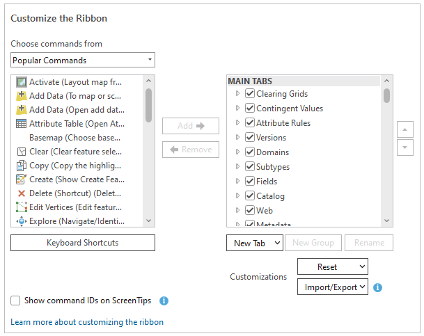
One of the coolest features of ArcGIS Pro is its customizable ribbon interface. Tailor it to fit your workflow and make frequently used tools more accessible.
To customize the ribbon, go to the “Project” tab inside ArcGIS Pro and select “Options.” In the “Options” window, navigate to “Customize the Ribbon”. Here you can create new tabs, add or remove commands, and rearrange tools to create a workspace that’s perfect for you. More details here.
2. Automating Tasks with Geoprocessing Tools and Python Scripting
ArcGIS Pro offers a range of geoprocessing tools to automate repetitive tasks. For more advanced automation, Python scripting is your friend. ArcGIS Pro integrates Python 3 and the ArcPy module, letting you create custom scripts for data manipulation, analysis, and visualization.
You can start scripting right within ArcGIS Pro’s built-in Python window. Additionally, ModelBuilder offers a visual way to create and automate geoprocessing workflows. Check out ModelBuilder for more details.
3. Leveraging Advanced Features
ArcGIS Pro comes packed with advanced features like 3D analysis, spatial statistics, and online integration.
- 3D Analysis: ArcGIS Pro’s 3D capabilities are a significant upgrade. You can create 3D scenes to visualize and analyze spatial data in three dimensions. Use the “3D Analyst” extension for terrain and surface analysis. More about 3D Analyst.
- Spatial Statistics: Advanced spatial statistics tools let you analyze patterns and assess relationships within your data. Tools like “Hot Spot Analysis” and “Spatial Autocorrelation” offer deeper insights. Explore spatial statistics.
- Online Integration: Seamlessly integrate ArcGIS Pro with ArcGIS Online and ArcGIS Enterprise. Publish maps, share data, and access a vast library of datasets. Learn more about ArcGIS Online integration.
4. Tips for Efficient Workflow
To maximize your GIS efficiency and workflow, we recommend these tips:
- Use Bookmarks: Save and quickly navigate to specific map extents or views, especially useful for large projects.
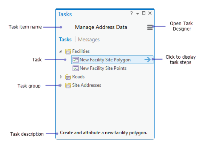
- Utilize Tasks: The “Tasks” feature guides users through multi-step workflows, ensuring consistency and saving time. Learn more here.
- Keyboard Shortcuts: Customize shortcuts for frequently used commands to speed up your workflow. Check out keyboard shortcuts.
Success Stories
Many organizations have successfully transitioned from ArcMap to ArcGIS Pro, reaping significant benefits.
- Erie Water Works (EWW) in Pennsylvania has implemented a GIS-based enterprise asset management system to bring engineering tasks in-house. This system uses ArcGIS software combined with advanced GPS and CAD technologies, enabling accurate, real-time data collection and reducing reliance on external consultants. The new workflows save significant time and money, improve data accuracy, and allow EWW to efficiently manage and update infrastructure assets. This has resulted in substantial cost savings and enhanced operational efficiency. For more details, read the full article here.
- North Carolina’s state broadband office is using GIS to map internet deserts and prioritize federal funding to bring broadband to rural areas. This initiative aims to bridge the digital divide, especially in underserved communities like Warren County, which received a $17.5 million grant to enhance connectivity. Accurate mapping of broadband gaps helps secure grants, informs project prioritization, and supports economic growth and equity in these regions. For more information, you can read the full article here.
Conclusion
Mastering Esri ArcGIS Pro unlocks a world of possibilities for GIS professionals. By customizing the ribbon, automating tasks, leveraging advanced features, and integrating online capabilities, you can significantly enhance your productivity and analytical prowess. With practice and the right resources, Esri ArcGIS Pro will become an indispensable tool in your GIS toolkit.

Jasen Kintner is Director of Research & Development at GEOGRAPH and has over 20 years of telecommunications experience. He has published research on network middleware protocols and intrusion detection, developed standards for computer networking, and managed telecom network strategy and planning. Since June of 2018, Jasen has been responsible for new product development at GEOGRAPH and has introduced CrescentLink Web Experience and CrescentLink for ArcGIS Pro. Jasen and his team help GEOGRAPH support over 160 customers in the United States, Canada, the British Virgin Islands, Bermuda, Guam, and Guyana.