
In the world of fiber network management, data is everything. Yet, while most organizations have invested in structured databases and GIS platforms, a vast amount of operational insight still lives in unstructured formats – handwritten notes, photos, sketches, field reports, and even emails. At the recent APEX 2025 Conference, one of the standout themes was the growing importance of integrating this unstructured data into geospatial workflows. For electric co-ops and utility providers, it’s a challenge, and an opportunity, that can no longer be ignored.

The Untapped Value of Unstructured Data
Unstructured data makes up over 80% of the information generated in day-to-day utility operations. Think about it: a field technician spots a splice issue and snaps a photo. An engineer leaves annotations on a printed map. A contractor emails a quick update from a site inspection. On their own, these snippets offer limited value. But when linked to a central GIS and layered with spatial data, they become powerful assets, helping teams troubleshoot faster, improve planning, and preserve institutional knowledge.
Unfortunately, many utilities still lack the tools or processes to make unstructured data useful. This leads to knowledge gaps, redundant field visits, and missed opportunities to optimise network health.
Why Utilities Are Taking a New Approach
At APEX 2025, industry leaders made one thing clear: as fiber networks expand, utilities must bridge the gap between structured and unstructured data. The ability to ingest, tag, and visualise freeform data alongside fiber routes, splice points, and access infrastructure is becoming essential for:
- Faster decision-making during outages or maintenance
- More accurate records when staff retire or move on
- Better planning and forecasting using a complete picture of the network
The shift is also being driven by advancements in machine learning and geospatial AI. Tools are emerging that can auto-classify photos, extract location metadata, and link notes to specific assets on the map, all with minimal manual input.
How GEOGRAPH Helps Utilities Make Sense of the Messy Middle
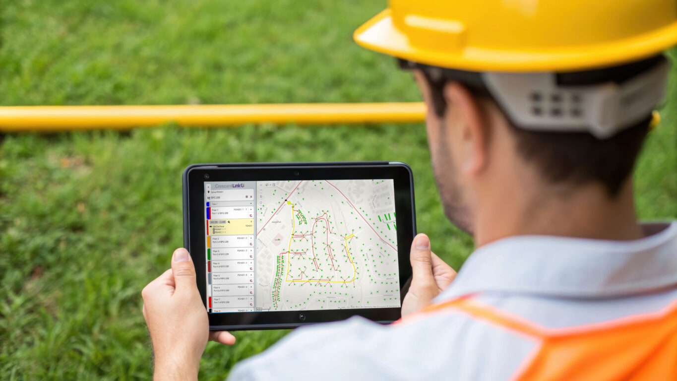
GEOGRAPH was built with this challenge in mind. Our GIS-based CrescentLink platform gives utility teams a centralised, scalable environment to manage both structured and unstructured network data. Here’s how we help unlock value from the data that usually gets lost in the shuffle:
- Centralised updates and documentation: CrescentLink acts as a single source of truth, ensuring that network records, including spatial and connectivity data, are updated in real time. This helps eliminate information silos and ensures all stakeholders have access to the latest data, reducing the risk of institutional knowledge loss.
- Web and mobile access: Field technicians can access and update network data remotely using mobile devices, allowing for real-time troubleshooting and modifications without needing to return to the office.
- Integrated network model: By providing a comprehensive digital map of fiber infrastructure, including cables, strands, splice points, and connections, CrescentLink gives teams full visibility into the network, which improves diagnostics, planning, and maintenance.
- Operational efficiency: Routine tasks such as fiber tracing, outage diagnostics, and work order tracking are completed significantly faster compared to manual or disjointed methods. Users report major time savings and reduced need for field visits thanks to tools like the Distance Trace and Network Manager.
The result? A living, breathing digital twin of your fiber network that captures not just what’s on the blueprint, but what’s happening in the real world.
Looking Ahead
As AI tools continue to evolve, the future of unstructured data in GIS is bright. Soon, we’ll see automated tagging of asset types in images, natural language processing of technician notes, and predictive models that surface recurring issues before they escalate.
But the key first step is clear: utilities need to start treating unstructured data as a core part of their network intelligence strategy.
GEOGRAPH is proud to help electric co-ops and utility providers take that step with intuitive tools, responsive support, and a platform designed for the complexities of modern fiber networks.